| |
MOUNTAIN MAPS & POSTERS
NO ON-LINE ORDERS ACCEPTED FOR SATELLITE IMAGE POSTERS AT THIS TIME. PLEASE EMAIL: randall@summitgeology.com OR TELEPHONE (303) 204-5394 FOR PRICES AND AVAILABILITY
|
COLORADO HIGH COUNTRY FROM SPACE Ski Runs at 12 Colorado Ski Areas Visible On This Satellite Image Lithograph!!
This 39" X 26" Satellite Image Wall Map contains never-before-seen detail of one of Colorado's favorite playgrounds. This striking image is presented at a scale of 1:126,720 or 1 inch equals 2 miles. At this very usable scale individual ski runs at 12 popular Colorado ski areas are visible including: Arapahoe Basin, Beaver Creek, Berthoud Pass (now defunct), Breckenridge, Copper Mountain, Eldora, Keystone, Loveland, Ski Cooper, Sol Vista (Silver Creek), Winter Park/Mary Jane, and Vail. This high-resolution image is also very useful to fishermen, hikers, cross-country skiiers, mountainbikers, and to just about anyone planning an outing in this approximately 3,750 square mile area. The image is presented in natural color and with the advantage of our precise color balancing technique will make both a good-looking as well as a functional wall hanging. Colorado High Country From Space is our most popular satellite image map.
|
COLORADO HIGH COUNTRY FROM SPACE satellite image posters are available by email or telephone request ONLY. NO ON-LINE ORDERS ACCEPTED.
PLEASE EMAIL: randall@summitgeology.com or CALL (303) 204-5394 for prices and availability. THANK YOU
| |
| Selkirk Mountains of British Columbia, Canada |
Revelstoke, Yoho, and Bugaboo Glacier National and Provincial Parks. Canada Heli-Skiing & Hut-Skiing Paradise!! The map includes locations of 22 Backcountry Huts.
The Selkirk Mountains of British Columbia, Canada. This area is a favorite destination of ski mountaineers and alpine climbers, as well as a popular tourist region on the Trans Canada Highway. Unparalleled alpine topography and favorable yearly snowfall in this region make the Selkirk Mountains a must on any mountaineers wish list. This striking 39" x 26" lithograph is presented in natural color at a scale of 1:250,000. The image features location and names of popular backcountry huts, road symbols, and geographic locations of important towns. This wall map was co-designed by Dr. Stan Wagon, a veteran of many trips into this interesting and alluring Canadian mountain range. This image is perhaps the best example of what our enlargement technique can do for the spatial understanding of alpine topography.
|
| SELKIRK MOUNTAINS FROM SPACE satellite image posters are available by email or telephone request ONLY. NO ON-LINE ORDERS ACCEPTED. PLEASE EMAIL: randall@summitgeology.com or CALL (303) 204-5394 for prices and availability. THANK YOU
|
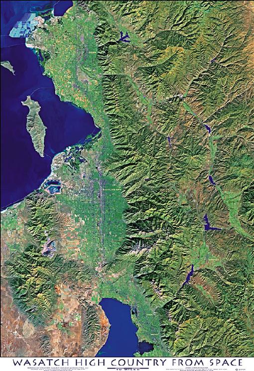
WASATCH HIGH COUNTRY FROM SPACE satellite image posters are available by email or telephone request ONLY. NO ON-LINE ORDERS ACCEPTED. PLEASE EMAIL: randall@summitgeology.com or CALL (303) 204-5394 for prices and availability. THANK YOU
|
|