| |
Desert Maps & Posters
ON-LINE ORDERS CURRENTLY UNAVAILABLE FOR ALL LITHOGRAPH PRINTS. PLEASE EMAIL: randall@summitgeology.com OR TELEPHONE (303) 204-5394 FOR PRICES AND AVAILABILITY
|
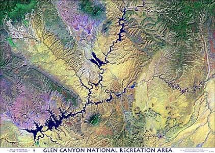
This Beautiful Scene Encompasses all of Lake Powell, Navajo Mountain, and the Grand Staircase/Escalante Region, and More! "Perhaps our most compositionally appealing image"
GLEN CANYON satellite image posters are available by email or telephone request ONLY. NO ON-LINE ORDERS ACCEPTED. PLEASE EMAIL: randall@summitgeology.com or CALL (303) 204-5394 for prices and availability. THANK YOU
| |
| High-Resolution Satellite Image Posters of the North American Desert are designed by John C. Dohrenwend, PH.D of Southwest Satellite Imaging. |
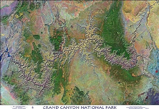
Grand Canyon National Park
This beautiful image of Grand Canyon National Park and surrounding area is presented at a scale of 1:250,000 and covers the entire span of the Grand Canyon from Marble Canyon in north-central Arizona to the Grand Wash Cliffs and the Nevada border in northwestern Arizona. This image is a digital color composite of infrared and visible light spectra that when combined produce an intuitive and quite natural looking image. This striking scene highlights the natural landscape of the Grand Canyon and surrounding areas by combining remarkable ground detail and presentation. The image is finely lithographed onto 39" x 26" poster stock.
GRAND CANYON NATIONAL PARK satellite image posters are available by email or telephone request ONLY. NO ON-LINE ORDERS ACCEPTED. PLEASE EMAIL: randall@summitgeology.com or CALL (303) 204-5394 for prices and availability. THANK YOU
| |
|