|
CUSTOM SATELLITE IMAGERY AT MAP SCALES FOR ANY GLOBAL LOCATION
|
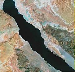 |
| Browse File Image: Red Sea and Sinai Peninsula-Egypt |
|
| Landsat Satellite Data is Collected From a Height of 438 Miles
To produce Custom Satellite Imagery for your study site or area of interest we first look at browse files of available Landsat scenes of the region. Browse files are typically at a scale of 1:2,000,000. The browse files enable us to ascertain certain parameters that must be met to produce a successful image including: month and year of fly-over, cloud cover, ground conditions, and resolution. If these parameters are optimal we can proceed to data acquisition and processing. Frequently two or more different scenes must be seemlessly joined to produce the desired ground footprint.
|
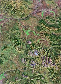 |
| Custom satellite image of Colorado and Roaring Fork River Valleys, Aspen - Glenwood Springs area. Scale 1:125,000 (roughly 1 inch equals 2 miles) |
|
| Color Enhanced Images
This proto-type produced for the area around Aspen and Glenwood Springs, Colorado is presented in false-color utilizing data from alternative spectra. The area includes the Elk Mountains and Glenwood Canyon of the Colorado River. Additional resolution and enhanced ground detail can be obtained with false-color plots. This image is scaled at 1:125,000 (1 inch equals 2 miles approx.), an effective regional scale.
|
|